

6 Gravel Bike Destinations

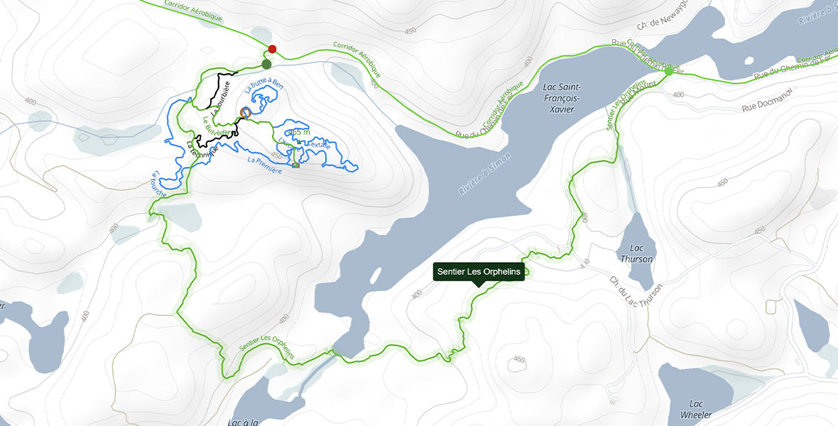
1. Parc du Corridor aérobique — Sentier des Orphelins
Starting in the charming village of Morin-Heights, the 58-kilometre Corridor aérobique bike path passes through Laurentian villages to Saint-Rémi-d’Amherst. For beginners, the gravel bike path alone is a great first experience, with an average slope angle of 5%. You’ll ride by vast lakes and admire the sublime Laurentian landscape.
For more experienced riders, the Corridor aérobic offers two off-road paths for an outstanding gravel ride. The first option, the CN, is located at the beginning of the Corridor. It’s part of the mountain bike network, but being a green beginner trail, it’s rideable on gravel bikes with knobby tires.
The second option is a little farther, past the municipality of Monfort. The Sentier des Orphelins stretches over 5.3 kilometres, including a steep climb at the start, with some climbs ranging from 6% to 7%. You should check it out!
You don’t yet have a gravel bike to explore this destination? Check out our article How to Choose a Gravel Bike?.
2. Arundel — Boileau — Harrington loop
If you’re interested in a long loop that’s mostly on unpaved roads, you’ll find what you’re looking for. This loop, starting at the Arundel Corridor aérobic parking lot, travels sixty kilometres, passing through Boileau, Rivington and Harrington. The last section of the route runs along the Red River. Bring enough water and snacks since you won’t necessarily come across any services.

3. Mount Hereford
If you want a tougher outing in terms of elevation gain and slope angle, Mount Hereford provides an excellent challenge. Starting from Saint-Herménégilde, the loop offers two options: either climb to the summit or ride around the mountain.
What should you expect on the climb to the mountaintop? A very steep, three-kilometre ascent culminating at 820 metres above sea level. Bring your grippiest tires and a dose of electrolytes! This itinerary is for experts, especially if you include the climb in your route.
Camping Villette in Saint-Herménégilde lets you enjoy a full weekend of exploring the surroundings on your gravel bike.

4. Mont-Orford — La Cavalière Trail
A more accessible loop, the La Cavalière trail, located in the Parc National du Mont-Orford, connects Lake Fraser to Lake Stukely. It can be done as an out and back or connected with other trails in Parc National du Mont-Orford, such as the route verte. The La Cavalière trail is about twenty kilometres and is never flat! Riders who like working on their handling skills will enjoy it. The La Cavalière trail is multi-use, so you’ll have to share it with hikers.

5. Mauricie National Park
Mauricie National Park’s mature, diverse forests and abundant wildlife are a magical landscape for a gravel bike adventure. The 55 km network of gravel trails through a rolling terrain of lakes, bogs, and creeks lets you create loops of various lengths by linking up the paths with the Parkway, the scenic paved road that runs through the park. Trail 9, which runs along Lac Édouard, is especially photogenic, with beautiful views over the water. Some trails have somewhat technical section with roots and muddy patches. That said, the lack of car traffic (only official park vehicles are permitted) makes for a peaceful ride.
For a longer outing of about 44 km, start at the Saint-Gérard entrance and link up trails 3, 8, 7, and 9. Then take the Parkway back to your starting point via trail 3 from the Rivière-à-la-Pêche Service Centre.
Camping is available in the park for multi-day rides.

6. Réserve faunique des Laurentides
For those ready to venture deep into the backcountry and rack up some serious elevation gain, the réserve faunique des Laurentides takes gravel biking to another level. Thousands of kilometres of forest roads wind through this vast wilderness. Dark evergreens dominate the boreal forest with scatterings of white birch. In places, the thick woods open onto mountain views or give way to lakes, rivers, and swamps lined with tamaracks. Signs of moose, porcupines, bears, wolves, or even caribou (for the lucky few) aren’t uncommon—and every so often, you can spot the animals themselves. Some roads are wide, but many are narrow and winding. Whatever path you choose, silence and solitude await.
Camp Mercier and L’Étape are two good places to park and start your ride. Be sure to avoid the lands owned by the Séminaire (southeast of the reserve), which are closed to the public.

The Best Apps for Planning Gravel Bike Rides
There are several apps that allow you to plan routes and let you consult the destinations shared by other users. One of them, Ride with GPS, allows you to create a route and analyze data, such as elevation, surface type, slope percentages and more.
Apps to try:
- Ride with GPS
- Komoot
- Gaia GPS
- Strava
- Google Maps can also give you a hand